
A CGI site masterplan is a planning-ready, computer-generated visual and data package that represents a proposed development’s layout, massing, context and landscape in three dimensions. It combines geo-referenced modelling, annotated plans, photorealistic renders and exportable data to communicate a scheme to planning officers, investors, marketing teams and design consultants. Visualtrick produces these outputs using licensed Ordnance Survey base mapping and verified photomontage practice, so every deliverable meets the evidentiary standards planning authorities expect.
TL;DR — what you get and when to use it:
- Core deliverables: 2D annotated plan overlays, 3D massing models, verified photomontages, aerial visualisations, flythroughs and interactive WebGL viewers
- Three primary uses: planning applications and pre-application engagement; off-plan marketing and investor presentations; optioneering and design review
- When to commission: as early as initial options testing, through pre-application discussions, and into the marketing phase once a preferred scheme is fixed
Table of Contents
- What is a CGI site masterplan, and how does it differ from a conventional site plan?
- What outputs does a CGI studio typically deliver?
- Why commission a CGI site masterplan?
- How is a CGI site masterplan produced?
- What affects timeline and cost on UK projects?
- What should your brief include?
- UK planning requirements and trust signals
- Where CGI site masterplans make the biggest difference
- Key takeaways
- The case for getting the brief right before the model starts
- Visualtrick: planning-ready CGI for developers and architects
- Useful sources
- FAQ
What is a CGI site masterplan, and how does it differ from a conventional site plan?
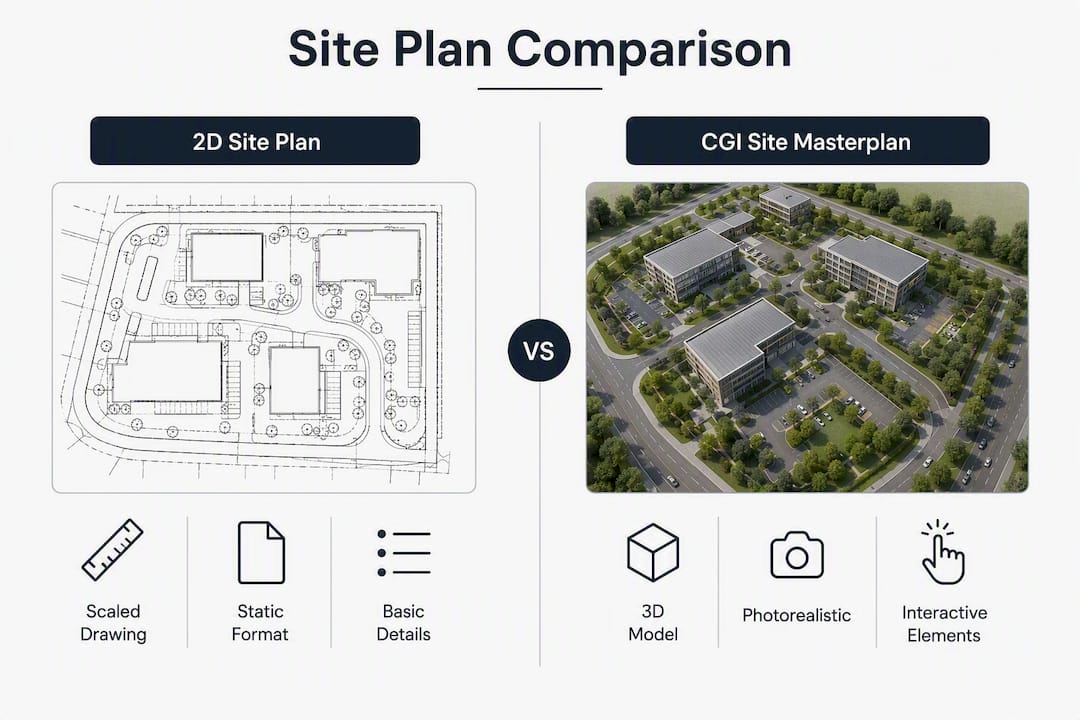
The terms “site plan” and “site masterplan” are used interchangeably in conversation, but they describe different things. A statutory 2D site plan is a scaled drawing submitted with a planning application to show plot boundaries, access points and building footprints. A CGI site masterplan is something broader: a strategic, three-dimensional framework that covers buildings, infrastructure, public space, landscape and phased delivery, tested visually across multiple design options before a preferred scheme is fixed.
According to Scottish Government planning guidance, masterplanning has no single fixed method — it moves through site appraisal, analysis, design options and testing iteratively. The CGI component sits within that process: it turns abstract proposals into images and data that non-technical stakeholders can read and respond to.
A site masterplan acts as a living document that guides a project from conception through to completion, supporting financing and permitting decisions along the way. The CGI layer makes that document legible to audiences who cannot read engineering drawings.
| 2D statutory site plan | CGI site masterplan | |
|---|---|---|
| Format | Scaled 2D drawing (PDF/DWG) | 3D model + rendered images + annotated plans |
| Primary purpose | Planning submission compliance | Design communication, optioneering, marketing |
| Audience | Planning authority | Officers, investors, buyers, design team |
| When produced | At planning application stage | From early options through to marketing |
| Scenario testing | No | Yes — multiple massing options |
| Geo-referenced | Sometimes | Yes, using OS/licensed mapping |
What outputs does a CGI studio typically deliver?
The deliverable set varies by project scale and budget, but most studios produce a recognisable core package. Understanding what each output is for helps you specify only what you actually need.

| Deliverable | Primary use | Typical format |
|---|---|---|
| Verified photomontage | Planning submission, officer engagement | TIFF/JPEG + metadata file |
| Annotated 2D plan overlay | Planning drawings, site schedule | PDF/DWG |
| 3D massing visualisation | Optioneering, design review | JPEG/PNG, FBX/OBJ |
| Aerial CGI | Marketing, investor packs | JPEG/TIFF |
| Flythrough animation | Marketing, public consultation | MP4/MOV |
| Interactive WebGL viewer | Stakeholder engagement, sales suite | Web-hosted URL |
| Site schedule PDF | Planning and sales |
CGI site plans present the arrangement of homes, roads, parking, footpaths, open space and landscape in a single visual, which is why they are so useful for housing developers who need to communicate a scheme to buyers before a single brick is laid.

Planning-ready outputs — verified photomontages and annotated plan overlays — carry photographic metadata, camera positions and sight-line annotations. Marketing assets such as aerial CGIs and flythroughs prioritise visual appeal over verifiability. Both serve the same project; they just serve different audiences. For a broader view of types of visualisation for property marketing, the deliverable choice depends on the audience and the stage of the project.
Why commission a CGI site masterplan?
The practical case is straightforward. Planning officers, investors and buyers cannot read a CAD drawing the way a design team can. A well-produced masterplan visualisation closes that gap quickly.
- Optioneering and risk reduction: testing massing, shadowing and movement flows in CGI costs a fraction of what it costs to revise a planning application after refusal. Visualising two or three layout options before pre-application discussions lets the design team arrive with evidence, not just proposals.
- Planning officer engagement: masterplanning provides a framework for land use, transport, utilities, public space and phased delivery, and CGI makes that framework readable to officers who process dozens of applications. A clear, annotated masterplan reduces the back-and-forth that delays decisions.
- Off-plan sales and marketing: aerial visualisations and flythroughs let buyers understand a scheme before completion. The role of visualisation in off-plan sales is well established — developers who invest in quality imagery at launch typically sell earlier and at stronger prices.
- Investor and JV presentations: an interactive viewer or option comparison pack gives joint venture partners a shared reference point. Decisions made from a clear visual brief tend to be faster and less prone to misunderstanding.
How is a CGI site masterplan produced?
The workflow runs in four broad stages. Each stage has clear inputs and outputs, and understanding them helps you brief a studio accurately.
-
Gather inputs. The studio needs a topographic survey, CAD or BIM files, Ordnance Survey licensed base mapping, title plans and any planning constraints (flood zones, heritage assets, protected views). The quality of these inputs directly determines the accuracy of the final model. Successful visualisation workflows reuse CAD/BIM, GIS and survey data to produce models that can be exported in standard formats for downstream use.
-
Geo-referenced modelling and massing. The studio builds a single federated model that places the proposed development accurately within its real-world context. This is where massing options are tested — adjusting building heights, footprints and orientation to explore what works before committing to a preferred scheme. An interoperable, geo-referenced model combining BIM and GIS reduces rework and speeds option testing considerably.
-
Visualisation: materials, landscaping, lighting and photomontage. Once the preferred massing is agreed, the model receives materials, planting, street furniture and contextual buildings. For verified photomontages, photographic metadata and a verifiable method are required so planning officers can check accuracy. Camera positions are fixed using survey-grade control, and focal lengths are recorded.
-
Post-production, QA and delivery. Final images are colour-graded, annotated and packaged with metadata. Planning images are delivered as high-resolution TIFF or JPEG with accompanying data files. Model files (FBX, OBJ, DWG) are supplied where the client needs them for downstream use. A typical project includes two structured review rounds before final delivery.
Typical timeline by deliverable type:
| Deliverable | Approximate lead time |
|---|---|
| Single verified photomontage | 2–3 weeks from survey data |
| Full 3D masterplan visualisation (3–5 views) | 4 weeks |
| Flythrough animation | 5 weeks |
| Interactive WebGL viewer | 6 weeks |
These ranges assume clean input data and a single round of client revisions. Incomplete surveys or late design changes extend every figure.
What affects timeline and cost on UK projects?
Cost and lead time are driven by a handful of variables. Knowing them before you approach a studio means you can scope the brief realistically.
- Level of model detail: a massing study with simple materials costs significantly less than a photorealistic render with bespoke landscaping, people and vehicles. Specify the level of detail you actually need for each deliverable.
- Licensed data: Ordnance Survey data carries a licence fee. Studios pass this on, and the cost varies by area and data product. Budget for it separately rather than treating it as a hidden overhead.
- Number of review rounds: each unplanned revision cycle adds time and cost. Agreeing a fixed number of review rounds (typically two) at the outset protects both parties.
- Animation and interactivity: flythroughs and interactive viewers require substantially more modelling and rendering time than static images. Phase these into a later stage if budget is tight early on.
- Procurement tip: phase the scope. Commission a massing study and two or three static views first. Once the scheme is fixed and pre-application feedback is received, commission the full marketing package. This approach avoids paying for high-quality renders that need to be redone after a design change.
What should your brief include?
A clear brief is the single biggest factor in getting the output you need on time and on budget. Studios that receive complete briefs deliver better work, faster.
Essential inputs to supply:
- Topographic survey (ideally LiDAR or total station, georeferenced)
- CAD or BIM files for the proposed scheme
- Title plans and site boundary
- Planning constraints map (flood risk, heritage, protected views)
- Design options with massing heights and footprints
- Material palette and landscape proposals
- Agreed photography points for photomontages
- Ordnance Survey reference data or confirmation that the studio will procure it
Decisions to make before briefing:
- Georeference specification: confirm the coordinate system (British National Grid is standard for UK planning)
- Photomontage verifiability: confirm whether images need to meet verified montage standards for planning submission
- Deliverable formats: specify which file formats you need (TIFF for planning, MP4 for marketing, FBX for model exchange)
- Intended audiences: planning authority, investors, buyers or all three — this affects the visual style and annotation requirements
- Review rounds: agree the number upfront and stick to them
Questions to ask a studio before appointing:
- What is your standard turnaround for this deliverable set, and what delays it?
- Do you hold an Ordnance Survey licence, and how is that cost handled?
- Who retains ownership of the model files after delivery?
- What is your revision policy, and how are out-of-scope changes charged?
Pro Tip: Ask the studio to confirm in writing that photomontage images will include camera position records, focal length data and a verifiable sight-line method. If they cannot confirm this, the images may not be accepted by a planning authority.
UK planning requirements and trust signals
Planning officers are not obliged to accept CGI as evidence. Images that cannot be verified — where camera positions are unknown, scale is ambiguous or context is misrepresented — can be challenged or dismissed. Getting this right is not a formality.
- Verified photomontage practice requires a fixed, surveyed camera position, a recorded focal length, date and time metadata, and sight-line annotations that show what is and is not visible from that point. The GLA’s guidance on verified montage practice sets out the expectation that images carry a verifiable method so officers can audit accuracy.
- Ordnance Survey licensing: base mapping used in planning images must be licensed. Using unlicensed OS data in a planning submission is a compliance risk. Confirm with your studio that they hold the appropriate licence and that attribution appears on all submitted images.
- Scale and annotation: every planning image should carry a north point, a scale bar, a title block and the date of the survey data used. These are not optional extras — they are what make an image a planning document rather than a marketing illustration.
- Integration with technical reports: CGI images are most effective when cross-referenced with the Design and Access Statement, the Heritage Impact Assessment or the Landscape and Visual Impact Assessment. A standalone image without a supporting narrative is easier to dismiss.
Pro Tip: Retain the source model files and all photomontage metadata. If a planning officer or third party challenges the accuracy of an image, an audit trail of survey data, camera records and model files is your defence. Studios should supply these as standard; if they do not, request them explicitly.
For a detailed walkthrough of what planning-ready CGI requires, Visualtrick’s architectural CGI planning submission guide for developers covers the process in practical terms.
Where CGI site masterplans make the biggest difference
Three scenarios come up repeatedly in UK property development where the investment in a CGI masterplan pays back clearly.
Pre-application and planning officer engagement. A verified photomontage and annotated masterplan submitted ahead of a pre-application meeting gives officers something concrete to respond to. Schemes that arrive with clear visuals tend to generate more specific feedback — which is exactly what a design team needs to refine a proposal before formal submission. Vague feedback (“we have concerns about massing”) is harder to act on than “the building reads as too tall from this viewpoint.”
Off-plan marketing and sales. Aerial CGIs and customer journey flythroughs let buyers understand a scheme’s character and layout before construction begins. For large residential schemes, this is not a luxury — it is how reservations are secured. Developers using high-quality aerial visualisations and CGI for planning applications as part of a coordinated launch package typically see stronger early reservation rates than those relying on floor plans alone.
Investor and JV pitches. An interactive viewer that lets a joint venture partner rotate a model, toggle between design options and zoom to street level communicates confidence in the scheme. For visualisation in joint venture proposals, the ability to show rather than describe a development reduces the time spent in alignment meetings and gives all parties a shared reference point from day one.
Common outcomes across these scenarios: fewer planning objections from consultees who have been shown the scheme clearly, faster stakeholder consensus, and a procurement brief that is specific enough for contractors to price accurately.
Key takeaways
A CGI site masterplan is the most effective tool for communicating a development scheme to planning authorities, investors and buyers before construction begins, provided it is built on verified, geo-referenced data.
| Point | Details |
|---|---|
| Definition | A CGI site masterplan combines 3D modelling, annotated plans and photorealistic renders into a planning-ready visual package. |
| When to commission | Commission from early options testing through pre-application discussions; update for marketing once the preferred scheme is fixed. |
| Planning trust signals | Verified photomontages require surveyed camera positions, focal length records and OS-licensed base mapping to be accepted by planning authorities. |
| Briefing priorities | Supply georeferenced survey data, CAD/BIM files, material palettes and agreed photography points before briefing a studio. |
| Visualtrick | Visualtrick delivers planning-ready CGI masterplan packages for UK developers and architects, using verified photomontage practice and licensed OS data. |
The case for getting the brief right before the model starts
Most delays and cost overruns on CGI masterplan projects trace back to the same source: the brief was incomplete when modelling began. A studio that starts work on a massing study before the survey data is georeferenced, or before the design team has agreed on building heights, will produce something that needs to be rebuilt rather than revised.
The conventional advice is to “brief thoroughly.” The more useful observation is that the brief is not a document you hand over once — it is a live agreement that needs to be confirmed at each stage gate. Before modelling starts: confirm the georeference specification and the massing options. Before visualisation starts: confirm the material palette and the camera positions. Before post-production starts: confirm the annotation requirements and the file formats for submission.
Studios that push back on an incomplete brief are doing you a favour. The ones that accept whatever arrives and start work immediately are the ones that generate revision cycles that eat into your programme.
There is also a tendency to over-specify the marketing deliverables and under-specify the planning ones. A flythrough is visible and impressive; a verified photomontage metadata file is neither. But the metadata file is what protects the planning case. Prioritise the planning-ready outputs first, then build the marketing package around them — not the other way around.
Visualtrick: planning-ready CGI for developers and architects
Visualtrick specialises in CGI for architects and property developers across the UK, producing planning-ready masterplan visualisations that meet the evidentiary standards planning authorities require. Every project uses licensed Ordnance Survey data, verified photomontage practice and structured review cycles, so what you receive is submission-ready, not just visually polished.

Whether you need a single verified photomontage for a pre-application meeting, a full 3D masterplan package for a major planning submission, or aerial and flythrough assets for an off-plan marketing launch, Visualtrick delivers clean, accurate visuals with the metadata and source files to back them up. To get started, prepare your survey data and CAD files, then request a quote for architectural visualisation — or get in touch to discuss the scope and receive a sample planning-ready output for your project type.
Useful sources
- Planning Advice Note 83: master planning (gov.scot) — Scottish Government guidance on the masterplanning process, stages and community engagement expectations.
- Master planning in AECO (Autodesk) — practical overview of how masterplanning integrates land use, infrastructure and phased delivery in architecture and construction.
- GLA verified photomontage guidance (consult.london.gov.uk) — sets out the verified montage practice expected for planning submissions in London, including camera records and sight-line annotations.
- Site master plan definition (Design Encyclopedia) — plain-language definition of a site masterplan as a living document supporting financing and permitting.
- Ordnance Survey licensing — authoritative source on OS data licences required when using mapping in planning submissions.
FAQ
Do planning authorities accept CGI as evidence?
Planning officers are not obliged to accept CGI, and images that cannot be verified, where camera positions are unknown or context is misrepresented, can be challenged or dismissed. Verified photomontage practice, with surveyed camera positions, focal length records and sight-line annotations, is what makes an image acceptable.
What outputs does a CGI studio typically deliver for a planning application?
Core planning deliverables are verified photomontages and annotated 2D plan overlays, usually supplied as TIFF or JPEG files with metadata, alongside PDF or DWG plan overlays. Marketing-focused outputs such as aerial CGI and flythroughs prioritise visual appeal over verifiability.
When should I commission a CGI site masterplan?
Commission as early as initial options testing, through pre-application discussions, and into the marketing phase once a preferred scheme is fixed. Phasing the scope, starting with a massing study and a few static views, avoids paying for high-quality renders that need to be redone after a design change.
