
For a permitted development project, the deliverables that consistently pass LPA validation are: existing-site photographs, a verified photomontage, a geolocated simplified massing model exported as FBX (with OS Grid or Lat/Long coordinates, units declared, and source software named), and annotated elevations with viewing planes. Brief a planning-experienced architectural visualisation studio to produce them. Visualtrick delivers all of these as a standard planning pack.
Core file and metadata checklist:
- Existing-site photographs from agreed viewpoints, with EXIF or GPS evidence of camera position
- Verified photomontage (composite of photograph and CGI render, with camera height and lens data documented)
- Simplified massing model in FBX format, geolocated by OS Grid reference (preferred) or Lat/Long
- Source software declared (e.g. SketchUp, Revit, Rhino, AutoCAD, 3ds Max) and units stated (m, cm, or mm)
- Annotated elevations and section drawings showing proposed changes in context
- Viewing planes and heritage context visuals where the site is near a listed building or conservation area
Table of Contents
- What do UK planning authorities actually require for permitted development?
- Which visual type suits each permitted development scenario?
- What software and export formats should you specify in the brief?
- A technical specification template to hand to your supplier
- How Visualtrick produces planning-ready visuals
- Key takeaways
- What most studios get wrong about planning submissions
- Visualtrick: planning-ready visuals, delivered to spec
- Useful sources and further reading
What do UK planning authorities actually require for permitted development?
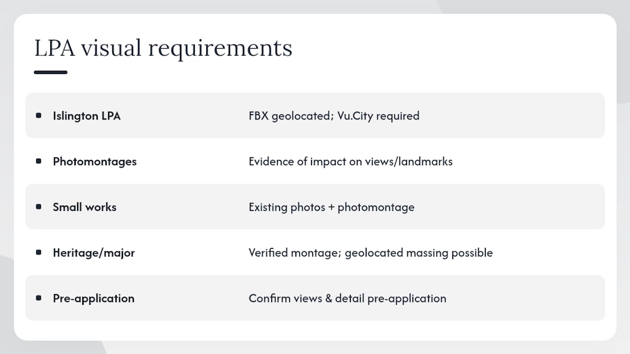
LPA validation lists are more specific than most applicants expect. Islington’s validation requirements set out that 3D massing models must be submitted in FBX format, geolocated by OS Grid coordinates (Lat/Long is accepted where OS Grid is unavailable), with all material and structural detail stripped out. The council uses Vu.City to analyse submitted designs, so FBX compatibility is not optional.
For photomontages and verified visual montages, the same guidance requires evidence of impact on designated views and landmarks. Where a proposal affects a protected view or the setting of a listed building, full 3D modelling may be required rather than a photomontage alone.
Scale and sensitivity determine how much visual material is needed. A small rear extension under permitted development rights rarely requires more than existing-site photographs and a photomontage. A larger roof extension, a change of use with external alterations, or any scheme near a heritage asset will typically need a verified montage and possibly a geolocated massing model. Pre-application discussions with the LPA are the most reliable way to confirm which views and which level of detail they will require before you commission anything.
National planning guidance reinforces this: supporting illustrations must be proportionate to the complexity of the application and must not substitute for adequate drawings. A well-produced photomontage supports the case; it does not replace the plans.
Which visual type suits each permitted development scenario?
Choosing the wrong visual type is one of the most common causes of validation delays. Here is how the main options map to typical PD scenarios.
Photomontage overlays a CGI render of the proposed development onto a photograph taken from an agreed viewpoint. It works well for small extensions, loft conversions, and minor external alterations where the council needs to see the proposal in street context without requiring full 3D analysis.
Verified photomontage goes further: camera position, height, and lens data are documented, the photograph is taken from a surveyed control point, and the compositing method is stated. Councils and heritage consultees expect this level of rigour for any scheme affecting a protected view, a conservation area, or the setting of a listed building.
CGI exterior is a fully rendered image produced from a 3D model, not composited onto a photograph. It suits marketing imagery and investor packs, and can be used in planning submissions where the LPA accepts rendered views rather than photomontages. Tower Hamlets’ CGI validation note confirms that CGI visualisations are required for all major developments, with views and format determined through pre-application discussions.
CGI interior rarely appears in planning submissions but is standard for marketing, investor presentations, and off-plan sales once permission is secured.
Simplified massing model is a geometry-only 3D file showing the building envelope with no materials, windows, or structural layers. Its sole purpose in a planning submission is spatial analysis: does the proposed volume fit the context? For permitted development, most LPAs will accept a verified photomontage plus a simplified FBX massing model rather than a full BIM export, which keeps costs and turnaround times manageable.
Heritage-sensitive sites are the exception. Where a scheme sits within or adjacent to a conservation area or affects a listed building, a written heritage statement, plans showing historic features, and 3D modelling to verify visual impact on the setting are all likely to be required.
What software and export formats should you specify in the brief?
Naming the right tools in your brief prevents re-submission requests. LPAs commonly ask for the source software and version alongside the model file, so your supplier needs to declare this explicitly.
Modelling tools accepted by most LPAs:
- SketchUp (widely used for massing; exports cleanly to FBX)
- AutoCAD (DWG/DXF for 2D plans and sections; can export 3D geometry)
- Rhino (precise NURBS modelling; strong FBX export)
- Revit (BIM-origin models; export simplified massing, not full BIM)
- 3ds Max (polygon modelling; native FBX support)
Rendering and real-time engines (Lumion, Twinmotion) produce the final CGI images and photomontage composites. They are not submitted to the LPA directly but should be named in the method statement so the council understands how the visualisation was generated.
Required export specifications:
- FBX for the geolocated massing model (OS Grid preferred; Lat/Long accepted)
- DWG or DXF for CAD plans and annotated elevations
- Units declared: metres for site-scale models, centimetres or millimetres for detail
- Source software name and version included in the delivery pack
- No construction layers, material textures, or structural internals in the massing file
Some councils, including Islington, use Vu.City to review submitted models. A clean FBX with correct geolocation loads directly into Vu.City without manual adjustment, which speeds the council’s review and reduces the chance of a validation query.
Pro Tip: Ask your modeller to include a one-page export checklist with every delivery: software name and version, coordinate system used, units, and a screenshot confirming the model’s position on the OS base map. It takes minutes to produce and removes the most common reason for re-submission requests.
A technical specification template to hand to your supplier
Use this table as the basis for a commissioning brief or as an appendix to a planning application.
| Deliverable | Format | Minimum metadata |
|---|---|---|
| Existing-site photographs | JPEG (high-res) | EXIF GPS or surveyed coordinates, camera height, date |
| Verified photomontage | JPEG/TIFF | Camera position, height, lens focal length, compositing method statement |
| Simplified massing model | FBX | OS Grid or Lat/Long geolocation, units (m), source software and version |
| Annotated elevations | PDF + DWG | Scale bar, north point, proposed vs existing overlay |
| Viewing planes diagram | Agreed viewpoints, distances, angles |
Verification checklist:
- Camera locations and heights documented for every photomontage viewpoint
- EXIF data or survey control point coordinates supplied for each photograph
- Short method statement (one page) describing compositing steps, control points, and lens correction
- FBX file tested for correct geolocation before delivery (screenshot of model on OS base map)
Sample filename conventions:
site_photos_view_A_01.jpgmontage_view_A_verified_v1.jpgmassing_model_OS_grid_v1.fbxelevations_annotated_proposed_v2.dwg
Typical turnaround and cost shape: a straightforward verified photomontage for a small PD scheme (one or two views) usually takes 5–10 working days from receipt of photographs and drawings. A geolocated FBX massing model adds 2–5 days depending on complexity. Fees are generally structured per deliverable rather than as a single project lump sum, which makes it easier to phase the work alongside the application programme. For a planning-ready CGI submission pack, expect to discuss scope and phasing with your supplier before agreeing a fixed fee.
How Visualtrick produces planning-ready visuals
Visualtrick’s process for a permitted development project follows a fixed sequence designed to produce LPA-ready artefacts at every stage.
End-to-end process:
- Briefing and site survey: agree viewpoints, photograph the site from surveyed control points, record camera heights and GPS coordinates
- Simplified massing model: built in SketchUp, Rhino, or Revit depending on the project; exported as FBX with OS Grid geolocation and units declared
- Photomontage compositing: CGI render composited onto the site photograph using matched camera data; lens distortion corrected; method statement drafted
- CGI exterior or interior production (where required for marketing or additional planning views)
- QA and verification artefacts: delivery pack includes the FBX, JPEG/TIFF montages, method statement, export checklist, and annotated elevations
Trust signals to request from any supplier:
- Geolocated FBX with OS Grid reference confirmed by screenshot
- Source software and version named in the delivery pack
- Camera position and height documented for each photomontage
- EXIF or GPS evidence for site photographs, or a survey control point record
- One-page montage verification statement covering compositing method and lens correction
Planning-grade accuracy and marketing fidelity are not in tension. A verified photomontage that satisfies an LPA’s validation checklist is also the most credible image you can show an investor or a planning committee — because it is demonstrably true.
For case study evidence, ask any supplier for anonymised examples of past planning approvals where their visuals formed part of the submission. A reputable studio can show approval notices or planning portal references without disclosing client details. Visualtrick’s architectural visualisation portfolio includes planning and marketing work across residential, commercial, and care sectors.
Key takeaways
Planning-ready permitted development submissions require a verified photomontage, a geolocated FBX massing model with source software declared, and annotated elevations — not a full BIM export.
| Point | Details |
|---|---|
| FBX is the required format | Submit simplified massing in FBX with OS Grid geolocation, units stated, and no structural or material detail. |
| Verified montage beats aesthetic CGI | A method statement documenting camera position, lens, and compositing steps is more persuasive to planners than multiple aesthetic revisions. |
| Pre-application discussions save money | Confirm required views and level of detail with the LPA before commissioning any visuals to avoid abortive work. |
| Name the source software | Declaring SketchUp, Revit, Rhino, AutoCAD, or 3ds Max in the delivery pack speeds council review and prevents re-submission requests. |
| Visualtrick for planning packs | Visualtrick delivers verified photomontages, geolocated FBX models, and annotated elevations as a complete planning-ready pack. |
What most studios get wrong about planning submissions
There is a gap between what looks good on screen and what actually passes validation. The most common cause of re-submission requests is not poor image quality. It is missing metadata: no camera height recorded, no OS Grid reference on the FBX, no method statement explaining how the montage was produced.
Planners are not assessing aesthetics. They are checking whether the visual evidence is verifiable. A photomontage without documented camera data is, from a validation standpoint, an unverified assertion. The council cannot confirm it is accurate, so they ask for it again, properly.
The non-obvious tip: supply a simple site-control photograph alongside the verified montage. Take one image of the camera tripod position with a scale rod or tape measure visible, and include the GPS coordinates in the filename. It takes two minutes on site and removes any ambiguity about where and how the photograph was taken. Planners notice when this level of care is present, and it signals that the rest of the submission is equally rigorous.
Visualtrick: planning-ready visuals, delivered to spec
Verified photomontages and geolocated FBX massing models are the two deliverables that most frequently determine whether a permitted development application validates first time. Visualtrick produces both, alongside annotated elevations, CGI exteriors, and full architectural visualisation services for planning and marketing.

Every commission includes a delivery pack with source software declared, OS Grid geolocation confirmed, and a montage verification statement ready to submit. Fees are structured per deliverable, so you pay for what the application actually needs. Turnaround for a standard one-to-two-view photomontage pack is typically 5–10 working days from receipt of site photographs and drawings.
To brief Visualtrick on your permitted development project, visit the CGI for architects service page or get in touch directly with your site address, proposed viewpoints, and LPA validation list.
Useful sources and further reading
| Source | What it covers | Why it matters |
|---|---|---|
| Islington Validation Requirements, April 2024 | FBX format, OS Grid geolocation, simplified massing, Vu.City usage, heritage requirements | Sets out the specific file and metadata standards that apply to 3D model submissions |
| Tower Hamlets CGI Visualisations validation note | When CGI is required, pre-application process, scale thresholds | Explains the ‘when required’ test and how views and format are agreed at pre-application stage |
| DCLG Guidance on information requirements and validation | National framework for proportionate supporting material and design statements | Confirms that illustrative materials must not substitute for adequate drawings and must be proportionate |
- Validation requirements update April 2024
- CGI Visualisations
- Guidance on information requirements and validation
